The Titanic Today
The RMS Titanic sank on its maiden voyage on April 15, 1912. One hundred years later, the wreckage of the Titanic is still sitting on the ocean floor.
COPYRIGHT© 2012 RMS TITANIC, INC; Produced by AIVL, Woods Hole Oceanographic Institute.
With her rudder cleaving the sand and two propeller blades peeking from the murk, Titanic’s mangled stern rests on the abyssal plain, 1,970 feet south of the more photographed bow. This optical mosaic combines 300 high-resolution images taken on a 2010 expedition. From the April 2012 issue of National Geographic.
The April 2012 edition of National Geographic magazine features the first ever complete views of the remains of the RMS Titanic, which you can see online. These images were constructed from thousands of high-resolution images, as the actual wreckage is larger than you can imagine. You could even describe it as "titanic!" Read how these amazing images were brought up from the depths in Unseen Titanic, by Hampton Sides. An excerpt:
The wreck sleeps in darkness, a puzzlement of corroded steel strewn across a thousand acres of the North Atlantic seabed. Fungi feed on it. Weird colorless life-forms, unfazed by the crushing pressure, prowl its jagged ramparts. From time to time, beginning with the discovery of the wreck in 1985 by Explorer-in-Residence Robert Ballard and Jean-Louis Michel, a robot or a manned submersible has swept over Titanic’s gloomy facets, pinged a sonar beam in its direction, taken some images—and left.
In recent years explorers like James Cameron and Paul-Henry Nargeolet have brought back increasingly vivid pictures of the wreck. Yet we’ve mainly glimpsed the site as though through a keyhole, our view limited by the dreck suspended in the water and the ambit of a submersible’s lights. Never have we been able to grasp the relationships between all the disparate pieces of wreckage. Never have we taken the full measure of what’s down there.
Until now. In a tricked-out trailer on a back lot of the Woods Hole Oceanographic Institution (WHOI), William Lange stands over a blown-up sonar survey map of the Titanic site—a meticulously stitched-together mosaic that has taken months to construct. At first look the ghostly image resembles the surface of the moon, with innumerable striations in the seabed, as well as craters caused by boulders dropped over millennia from melting icebergs.
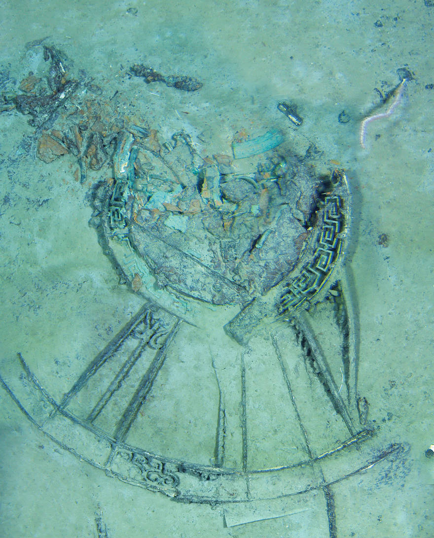
On closer inspection, though, the site appears to be littered with man-made detritus—a Jackson Pollock-like scattering of lines and spheres, scraps and shards. Lange turns to his computer and points to a portion of the map that has been brought to life by layering optical data onto the sonar image. He zooms in, and in, and in again. Now we can see the Titanic’s bow in gritty clarity, a gaping black hole where its forward funnel once sprouted, an ejected hatch cover resting in the mud a few hundred feet to the north. The image is rich in detail: In one frame we can even make out a white crab clawing at a railing.
Here, in the sweep of a computer mouse, is the entire wreck of the Titanic—every bollard, every davit, every boiler. What was once a largely indecipherable mess has become a high-resolution crash scene photograph, with clear patterns emerging from the murk. “Now we know where everything is,” Lange says. “After a hundred years, the lights are finally on.”
COPYRIGHT© 2012 RMS TITANIC, INC; Produced by AIVL, Woods Hole Oceanographic Institute.
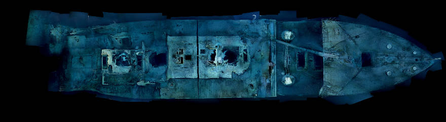
Ethereal views of Titanic’s bow offer a comprehensiveness of detail never seen before. The optical mosaics each consist of 1,500 high-resolution images rectified using sonar data. From the April 2012 issue of National Geographic.
COPYRIGHT© 2012 RMS TITANIC, INC; Produced by AIVL, Woods Hole Oceanographic Institute.
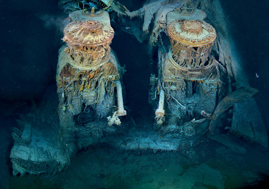
Two of Titanic’s engines lie exposed in a gaping cross section of the stern. Draped in “rusticles”—orange stalactites created by iron-eating bacteria—these massive structures, four stories tall, once powered the largest moving man-made object on Earth. From the April 2012 issue of National Geographic.
COPYRIGHT© 2012 RMS TITANIC, INC; Produced by AIVL, Woods Hole Oceanographic Institute.
Aft grand staircase dome
Decorated like the forward grand staircase dome featured in the movie Titanic, the aft grand staircase led down to the deluxe a la carte restaurant, allowing patrons to arrive in style. From the April 2012 issue of National Geographic.
COPYRIGHT© 2012 RMS TITANIC, INC; Sonar mosaic developed by Remus Operations Group (WHOI) and Waitt Institute.
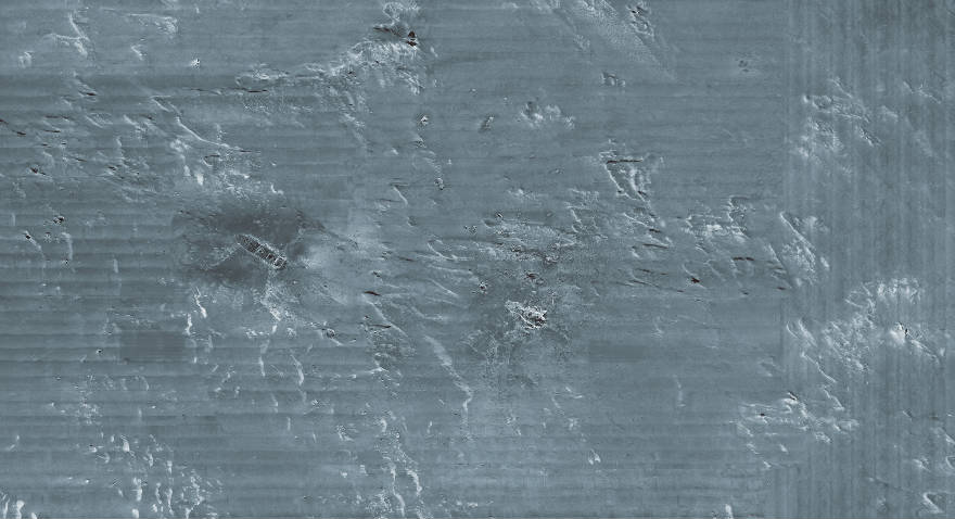
Visible for the first time through sonar imaging, the remains of the ship and its contents sprawl across a thousand acres of gently sloping seafloor. Combined with optical mosaics of individual artifacts, this map of the main wreck area will help experts explore, manage and protect the Titanic as a long-term archaeological site. From the April 2012 issue of National Geographic.
These images are from the April 2012 issue of National Geographic magazine. See them and read the accompanying article Unseen Titanic at NatGeo.
(YouTube link)