Have you noticed the strange phenomena of ice cream that doesn't melt? When a child drops a scoop or a novelty in your yard, you get the kid another and let the ice cream melt. Then you can pick up the stick and hose the cream down. But in the 21st century, you are liable to come back hours later and find a blob of ice cream still sitting there. I noticed this when my freezer died and a box of ice cream sandwiches sat there warm and intact.
Homemade ice cream contains milk, cream, sugar, and flavoring (and sometimes eggs and/or salt). The big conglomerates who sell store-bought ice cream have found ways to recreate that product with less of the expensive cream by adding gums and emulsifiers that enable them to whip in more air to produce volume. This includes premium brands like Breyers and Ben & Jerry's. These formulations often bring the product below legal standards for ice cream, but it doesn't matter if you grab a familiar package from the frozen food section. Look carefully, and you may find that it doesn't say "ice cream" anywhere on the package. Read how these frozen dairy desserts are made and how far they've strayed from "ice cream." -via Fark
Miss Cellania's Blog Posts
The smallest countries of Oceania, spread across the Pacific, are widely-spaced paradises. They aren't rich, but some of them make a surprising amount of money by getting creative and looking to the future. Vanuatu makes a ton of money by selling citizenship. Tuvalu prospers by leasing its .tv internet domain. And Tonga was fortunate enough to be the retirement home of a satellite expert, who saw a fortune in the starry skies above his new homeland. There's money to be made in selling, or in this case renting, what you have plenty of. For Tonga, that was its isolation, which gave them a large swath of the empty space overhead. Half as Interesting explains how Tonga leveraged its location and international pacts about the use of space to make millions of dollars passively. What happened to the money is another story. This video is only around five minutes- the rest is advertising.
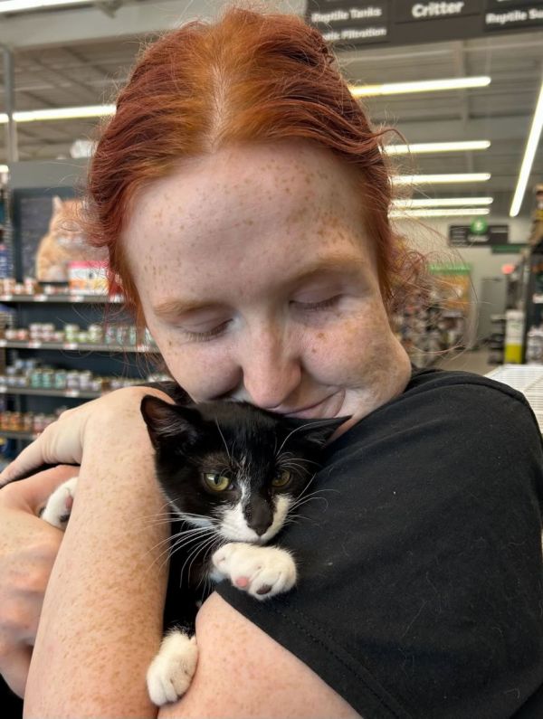
Stephanie Stullich of Beltsville Community Cats, a shelter in Maryland, received a call from Pet Supplies Plus that one of their kittens has been stolen from the store. She went down to the store and saw police cars arriving from all directions. She thought, "Wow, that's a heck of a response for a stolen cat." But there was more to the story.
On Monday, July 13th, a yet-unnamed man came into the pet supply store and stole the kitten. Employees said he had been there many times, showing great interest in the three-month old tuxedo kitten named Magnolia. Then he went across the parking lot to a bank and tried to rob it! He asked the bank manager to hold the kitten while he wrote a note, which was a note to the teller demanding money. He didn't get away with it.
Magnolia was stashed in the manager's office until she could be picked up, and was not hurt in the incident. Since she is no longer listed at the shelter's PetFinder page, we assume that the publicity of her adventure led her to a permanent home. Read or listen to the story at I Heart Radio. -via Strange Company
(Image credit: Beltsville Community Cats at Facebook)
Oh look! It's July, and we have a trailer for a Christmas ghost story! The trailer says "The name you know, the story you don't." Hogwash. Everyone knows the story of Charles Dickens' A Christmas Carol. There have been over a hundred movie and TV adaptations of it. Knowing the story doesn't keep us from watching it again and again. The 2026 version titled Ebenezer stars Johnny Depp in the title role, along with Rupert Grint as Bob Cratchit, Daisy Ridley as his wife, and Ian McKellen as Jacob Marley.
The trailer focuses on the star power of Depp and the many oddball characters he's played before. We can assume with this cast that the acting will be good. As far as I'm concerned, the success of Ebenezer will depend on how they portray the ghosts. Meanwhile, it is kind of nice to see scenes of falling snow while we swelter in the summer heat. Ebenezer opens on November 13th.
At the beginning of World War II, the Soviet Union had an agreement with Hitler to split conquered territories in Europe. The Soviets deported up to a half-million people from occupied Poland to labor camps in Siberia. In 1941, the USSR changed sides when Hitler double-crossed them. So what would they do with the Polish exiles now? Men were recruited for a Polish military unit, and tens of thousands of women and children were evacuated to Iran. From there, no one seemed willing to step up and take the refugees. The British considered settling them in India, but the Indians, who were suffering from wartime shortages like everyone else, were hesitant. Especially at risk were hundreds of malnourished Polish orphans, whose parents had died in transit or in Siberia.
Digvijaysinhji Ranjitsinhji Jadeja was the wealthy maharaja of Nawanagar, one of the local rulers who operated semi-independently but still under British authority. He stepped forward and said he would take all the orphans, risking his position by bypassing British permission. He personally welcomed the orphans, and had a camp built at his summer palace to accommodate them, complete with a school, a library, kitchens, and even a Catholic church. Before the war's end, Digvijaysinhji would take in around a thousand children. Read about Digvijaysinhji and the Polish children he adopted at Smithsonian. The article includes an hour-long documentary about this little-known chapter of history.
"Neither snow nor rain nor heat nor gloom of night stays these couriers from the swift completion of their appointed rounds" is an informal motto of the US Postal Service. However, mail carriers are not obligated to deliver your mail when you're obviously messing with them.
Vlog Creations, a YouTube channel dedicated to non-harmful pranks, invested in a long series of mailboxes of varying sizes and heights, and gradually installed smaller and smaller ones to see how long it took for the mail carrier to notice. Yeah, he noticed, but he's more amused than annoyed. Then it became a battle of wits to see how small they could make the box and still get their mail picked up and/or delivered. My mail carrier will never pick up outgoing mail unless he has some to deliver. This carrier put up with ridiculous challenges all the way through.
You can see a much longer video detailing this prank here.

Living in a castle isn't all that great, since they are hard to heat and the wifi is often blocked -and plumbing can be a nightmare. But we still swoon when we see the grandeur of what was built centuries ago. The interactive map Castlemap will help you discover new historic castles and fortresses all over the world. As you might guess, Europe has always been big on castles- notice you can recognize the area in the screenshot above just by the dots. Zoom in to separate them. Germany has many, but in Luxembourg, you can't swing a cat without hitting a castle. The same in Japan. In the US, most are military forts. You can sort the map by date or type of landmark.
It's not just a map, though. Click on any dot to bring up more information, collected from Wikidata and Wikipedia. Check out a list of the most famous castles, with links to more information and images. Sadly, there are no floor plans in this map. -via Metafilter
Watching someone open a box has never been my cup of tea, but what's inside this one is pretty cool. Gillian Anderson comes out of retirement to portray FBI Special Agent Dana Scully confronting a mysterious delivery. Inside is the new 1,478-piece LEGO set depicting The X-Files TV series! It was submitted to LEGO Ideas by Brent Waller of Brisbane as part of the LEGO Ideas ’90s Nostalgia Challenge. It has Fox Mulder’s office on the bottom, topped by an eerie forest scene, over which a UFO is hovering. It includes eight minifigs, both human and alien.
Kids won't be all that excited about this theme, since the show ran from 1993 to 2002, although there have been a couple of feature films since then. But adult fans will want to check out the set, and read more about its features here. The X-Files set will be available on August 4th, or August first if you're a LEGO Insider. -via Laughing Squid

There is a theory that an area of China once called Liqian was settled by around 145 middle-aged Roman soldiers more than two thousand years ago. Roman Legionnaires smack-dab in the middle of China? A clue may lie in the place name, as Liqian was used to refer to the Roman world. The story goes that the Roman army lost the Battle of Carrhae in 53 BC near where Turkey and Syria meet today. That's historical. Thousands of Romans were captured and sent east to defend other parts of the Parthian Empire in Central Asia. In 36 BC, 17 years later, another battle occurred, and the Chinese captured 145 soldiers as prisoners. They were taken to northwestern China to serve as border guards.
Can any of this story be true? There are some artifacts found in the village of Zhelaizhai that point to the possibility, and some residents show European features. Locals believe in their Roman ancestry. However, the more likely explanation is the Silk Road, which had been used by traders from all over long before those battles. Read up on the evidence for and against this theory at Amusing Planet.
(Image credit: Emilio Rubio Villanueva)
H. H. Holmes is often called "America's First Serial Killer," but if you say that, people will cite Albert Fish, Boone Helm, or the Bloody Benders as earlier examples. And there may have been others we don't know about. Be that as it may, Holmes was terrifying- once he got caught. That's when the secrets of a building he owned were revealed, and it became known as the Murder Castle.
But we still don't know the extent of Homes' crimes. He confessed to 27 murders, but not all those people were even dead at the time. Some estimate the total to be in the hundreds, but he was only convicted of one murder. Historians have since confirmed at least nine victims, and suspect many others. Homes had plenty of other crimes in his history, too, and the part of his story that may be the most shocking is how many red flags were ignored before he was finally stopped. Weird History tells us what we now know about Dr. Henry Howard Holmes, which wasn't even his real name.
The sequel to Mel Brooks' Spaceballs has been 40 years in the making. Well, maybe not, more like 35 years in limbo and is now in the making. Sadly, it won't be Spaceballs: The Search for More Money, but instead will be titled Spaceballs: The New One. And since 1987, there has been plenty of new Star Wars material to parody.
The plot of Spaceballs: The New One seems to be following in the footsteps of The Force Awakens, with a second generation of our heroes from the first film. Bill Pullman returns as Lone Starr, and the actor's son Lewis Pullman will play Prince Starburst, the offspring of Lone Starr and Queen Vespa. Starburst and friends "must find Lone Starr, Yogurt, and any other iconic legacy characters fans are demanding," which pretty much echoes the entire Star Wars sequel trilogy. Still, The Force Awakens was very much like a reboot of the first Star Wars movie from 1977 with some fresh faces, and Spaceballs: The New One isn't above doing the same thing. Read what we know about the movie at Inverse. Spaceballs: The New One is scheduled to open on April 23, 2027.
You can argue about the First Amendment and freedom of speech all day, but when it comes down to individual words and their spelling and usage, we defer to linguist Dr. Erica Brozovsky. She's not a stickler for correct usage, but she does keep an eye on how languages develop and change over time. Today, Brozovsky explains how certain governments have tried to standardize certain words, even names, either to protect a language or possibly to resurrect it.
Users of the English language, however, don't like to be told how to speak and write, which is why it has splintered into British English, American English, Australian English, etc. We have language authorities, more from academia than from governments, that tell us the correct way to spell and use English words, but even they are aware of how language changes and evolves due to the way real people use it in everyday life.

The business world loves to tell how the invention of the automobile wiped out the carriage making business. Yet the coachbuilder D’Ieteren is still thriving 221 years after its founding. It's made the D’Ieteren family the richest in Belgium today, although they no longer make carriages. Instead, each generation has learned to pivot from one business to another by leveraging the craftsmanship they already knew. D’Ieteren went from carriages to building auto bodies to importing cars to automotive glass- but not all at once. They gradually slid into each product as they noticed the market, while many carriage companies just gave up because no one bought horse carriages anymore.
You might not care a bit about the richest family in Belgium, but the moral of the story is that a business, or a person, can get caught up in their current profession thinking that's all they can do because it's what they do best. If you let go of thinking about what you do in your job, and start thinking about your overall mission instead, it's easier to pivot to what else you might be good at. I did this accidentally when I left my last radio job and decided the business was no longer compatible with my family life anyway. So I turned my blogging hobby into a profession, and was surprised that so many seemingly disparate skills I learned in radio benefitted my online work. Read about the D’Ieteren family business and what we can learn from it at Big Think.
(Image credit: André Ritzinger)
Can you recall all the reasons you loved the 1987 movie RoboCop? Was it because of the cool robots and the violent action scenes? Was it because of your empathy for the character Alex Murphy, who was doomed to live as a robot- as long as he was useful? Is it because of its satirical take on government corruption, corporate monopolies, and late-stage capitalism? That may depend on how old you were at each viewing. But there are other reasons that RoboCop is held in cinematic high esteem.
Forty years later, RoboCop holds up better than most action films of the '80s because it just plain looks good. Dutch director Paul Verhoeven was criticized by some at the time for his European style of filmmaking, but overall, his care for crafting each scene as a work of art paid off, and audiences didn't even know it. Rowan J Coleman breaks down what Verhoeven did to make RoboCop a timeless film. There's an ad from 5:58 to 6:37. -via the Awesomer

It is thought that Vladimir Lenin, the founder of the Soviet Union, is the subject of the most non-religious statues on earth, even after many were toppled in the early 1990s. In December of 1958, a Soviet expedition reached Antarctica's Pole of Inaccessibility, the point of the continent furthest from any coastline. They arrived in tractors, and build an airstrip and several buildings. They also erected a substantial bust of Lenin atop the chimney of one of the buildings. The plane that picked them up left a generator, a radio transmitter, and stores of food. But no one ever used that research station. A few Soviet and American expeditions visited in the 1960s, but it was mostly forgotten afterward. After all, it wasn't easy to find, much less get there.
In 2007, a British team reached the Point of Inaccessibility on kite skis. They found the research station completely gone, buried under Arctic snow and ice, with only Lenin remaining, looking toward Moscow. Read the story of the inaccessible Lenin statue at Boing Boing.
(Image credit: Cookson69)