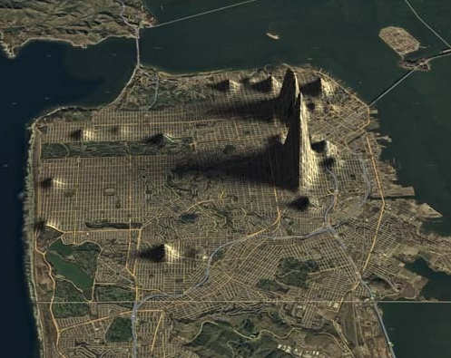
Topographical Crime Maps

By John Farrier in Crime & Law on Jun 8, 2010 at 1:13 pm

Doug McCune, who descibes himself as a “data visualization engineer”, created 3D crime maps for San Francisco. They look like topographical elevation maps because raised portions represent reported criminal incidents. Pictured above is a display of prostitution in the city.

Link via io9


Email This Post
Tweet This Post 
Share This Post on Facebook

Tags: ,


Neat stuff from the NeatoShop:


  1. werD
    Jun 8th, 2010 at 1:38 pm

    So next time you’re in San Francisco looking for a prostitute, head for the very tall hill.

  2. Peach
    Jun 8th, 2010 at 3:58 pm

    Where are other cities? this is cool -I would like to see more places.

  3. Rocky
    Jun 8th, 2010 at 5:25 pm

    Looks very close to the Castro District. I’m sure it’s just an anomaly.

  4. monkey_town
    Jun 9th, 2010 at 1:26 am

    I thought it said “Typographical Crime Maps” and it pinpointed areas where people had poor spelling.

  5. Kalel
    Jun 9th, 2010 at 11:12 am

    So… The prostitues are where the humps are?

  6. Ron D-
    Jun 9th, 2010 at 7:44 pm

    No where near the Castro district just off of the right end of the rectangular Golden Gate park that runs inland from the Pacific Ocean to the left.

    The big peak is the “South of Mission” district and the next larger is near the Nob and Russian hill districts. Guess it fits that nearly the largest peak is where the bankers, railroad tycoons, etc., used to have their mansions.


Keep track of the comments with Comment RSS

Don't Miss: New Stuff | Bestsellers | The Cute Store
                   Funny T-Shirts

Need a gift? Get unforgettable gifts for:
Geeks | Pranksters | Kids | Hipsters | Shutterbugs

Lijit Search

Old school? Bookmark us! RSS Feed Twitter Facebook Page