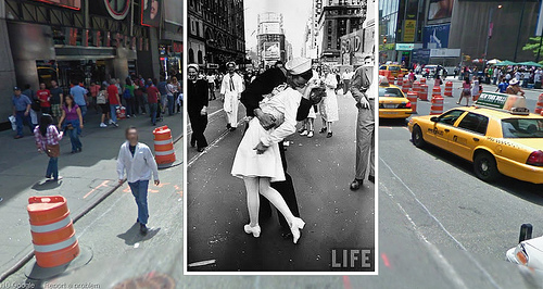
Historypin is a crowdsourced project that places historical images and the events associated with them over pictures from Google Street View. Users are invited to submit their own pictures and stories to contribute to a world map of history.
Thinks about how awesome this could be in a few years when there's an augmented reality app for cell phones.
Link via reddit
Newest 4 Comments
Many Google Street View Privacy Invasions found here: Google Street View
Abusive comment hidden.
(Show it anyway.)
@hmmm -- just keep scrolling the map around. I found several in the U.S.
Abusive comment hidden.
(Show it anyway.)
Sounds like a less interactive version of the geographic hacking described in William Gibson's SPOOK COUNTRY.
Abusive comment hidden.
(Show it anyway.)
is it just me or is this pretty much only for the UK?
Abusive comment hidden.
(Show it anyway.)