 1925 Tri-State Tornado Damage, NOAA Archives
Neatorama is proud to bring you a guest post from history buff and Neatoramanaut WTM, who wishes to remain otherwise anonymous.
In the early afternoon of March 18, 1925, there occurred over the Ozark Mountains of Missouri a mysterious weather phenomenon that had never before been observed and has not been observed since, this being the genesis of a one-of-a-kind (thus far) monster of a storm that was to become known as the Tri-State Tornado.
It was the very end of winter, but temperatures in Missouri were unusually warm for mid-March, a balmy 65 degrees. Although each spring brought the threat of tornadoes to Tornado Alley, severe weather usually wasn’t a concern at this latitude until May, and after all, it was technically still winter. No one in the immediate area knew it, but a confluence of three independent weather systems had recently taken place overhead, an event that was soon to have the severest of ramifications. A low-pressure cyclone from Canada had brought cool dry air, a warm front drawn from the Gulf of Mexico by this low-pressure cyclone had brought warm moist air, and another warm front drawn from the desert southwest had brought warm dry air.
The confluence of the three weather systems intensified the cyclone which had by then centered over the midwest, in which then developed unseasonable squall lines of severe thunderstorms, among them a massive type of mesocyclonic (rotating core) thunderstorm known as a supercell. Supercell thunderstorms are one of nature’s danger signals, like rattles on a rattlesnake, for they invariably produce severe weather such as torrential rain, golfball-to-grapefruit-sized hail, hurricane-force downbursts – and tornadoes. One ignores a supercell thunderstorm at one’s own peril, as thousands of people across three states were about to discover.
This particular supercell formed over the Ozark Mountains in Reynolds County, Missouri, in the southeastern corner of the state, as part of a related outbreak of twelve tornadic thunderstorms embedded in the squall lines, all of which were deadly and destructive in their own right. Although no one claims to have witnessed the touchdown of the tornado it spawned just before 1 pm, a rural mail carrier about three miles north of Ellington, Missouri, reported seeing and hearing an “awful commotion” plunging across the land in front of him shortly after 1 pm.
Thus began what was to become the deadliest tornado disaster in the history of the United States. Over the next three-and-a-half hours, 695 people would be killed in Missouri, Illinois, and Indiana (hence the name Tri-State Tornado), with still more dying later from their injuries, and at least two thousand more would be badly injured or maimed for life. By the end of its run, the storm would also demolish 15,000 homes and hundreds of family farms. Some few towns would be completely destroyed; all others in its path would be partially or mostly destroyed.
 1925 Tri-State Tornado Damage
A combination of circumstances made this storm so extraordinarily deadly and destructive:
1. It was still winter; people simply weren’t expecting a tornado then in that area of the country
2. Eyewitnesses reported the tornado’s general appearance as a “smoky fog”; a funnel cloud or clouds were not evident for nearly its entire path, so most victims didn’t realize the storm was a tornado until it was far too late to escape. Its great forward speed, as high as 73 mph, gave little time to make for cover once it had been recognized as a tornado
3. It was an F5 tornado, which, with its great forward speed, gave it an effective wind velocity of well over 300 mph
4. The US Weather Bureau then did not allow forecasting of tornadoes or warning of tornadic conditions (a practice that, incredibly, was continued well into the 1950’s) because such forecasts produced ‘panic’ among the locals affected. (Apparently, it was acceptable to the federal government for you to be killed by a tornado, just so long as you did not panic beforehand.)
5. The supercell thunderstorm formed within the cold front, about 80 miles behind the ‘triple-point’ intersection of the three fronts, a most unusual location for such development, and the low-pressure cyclone intensified by its confluence with the two warm fronts moved at just the right pace to keep its offspring supercell and its tornado in a favorable tornadic environment for the astonishing and unprecedented duration of three-and-a-half-hours
6. The damage track was continuous and uninterrupted for 219 - 235 miles (opinions vary); there was no hopping or skipping, although the width of the track did vary from one-quarter to nearly one-and-one-half miles
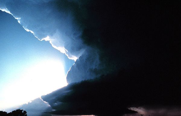
Judging from the many eyewitness accounts, the Tri-State Tornado was most probably a massive circulating multi-vortex, at times possessing two or three funnels that repeatedly combined and separated, all wrapped in rain and “smoky fog” that was part of a high precipitation (HP) supercell updraft. Occasionally the condensation funnels (the familiar ‘funnel cloud’) would (and did) become visible; but most of the time, they would have been (and were) enshrouded and hidden by a rotating veil of rain curtains and ‘fog’ that depleted and reformed constantly over nearly all of its life. Contemporary observations indicate that heavy ‘rain shafts’ can resemble low clouds and fog on the ground, and the Tri-State Tornado’s parent supercell was undoubtedly of the HP type. One eyewitness account runs thus: “All morning, before the tornado, it had rained. The day was dark and gloomy. The air was heavy. There was no wind. Then the drizzle increased. The heavens seemed to open, pouring down a flood. The day grew black. Then the air was filled with 10,000 things.”
No photographs of the Tri-State Tornado are known to exist (it was 1925), but judging from the eyewitness accounts it must have at some point looked something like a composite of these two HP supercells. Note the underlying and impenetrable darkness seen in both images, especially the second, (“the day grew black”) and the close proximity of the cloud bases to the ground (“it was a purple-black mass rolling over and over like a barrel”). The supercells shown are themselves massive and probably much like the supercell that spawned the Tri-State Tornado.

Some meteorologists and storm chasers are of opinion that the April 2011 Birmingham tornado, as seen in this embedded video, is more representative of the camouflaged and rain-wrapped multi-vortex tornado that the fully-developed Tri-State Tornado must have been. Unfortunately, no one shall ever know for certain.
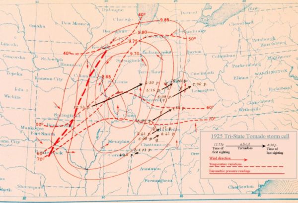
The Tri-State Tornado followed a path that closely matched those of other tornadic storms occurring in the US, i.e., from southwest to northeast. Only near the end of its life did it deviate slightly, turning 9 degrees north near Owensville, Indiana. The map below shows its path, from its first reported sighting to its last, and embedded commentary describes the death and destruction that it wrought along the way.
 Track of the Tri-State Tornado as published by Wilson and Changnon (1971). Speeds they deduced for the tornado’s progression and other data are shown along the track.
The Tri-State Tornado mesmerized many of those who saw it, which may also help explain why it proved to be so deadly. There are eyewitness accounts of the storm clouds possessing unusual colors and appearance, these coming from those who had not then recognized the storm as being a tornado. In one such account, two young women are standing in a house’s dining room, admiring the “beautiful cloud” that one of them had spied through the window, and they were still standing there in rapt admiration when a 600 lb cast-iron stove came crashing through the wall.
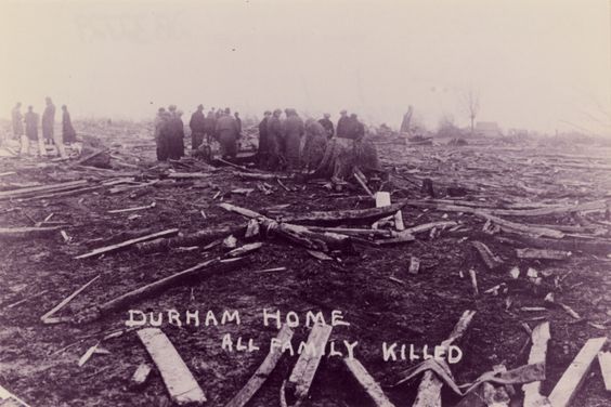
Damage throughout the Tri-State Tornado’s track frequently approached total destruction. Following are typical examples of what resulted, sadly and all too often, when the storm passed through inhabited areas.
 1925 Tri-State Tornado Damage
 1925 Tri-State Tornado Damage, West Frankfort, Illinois
The level of destruction observed in DeSoto, Illinois, was eerily evocative of that seen in Hiroshima 20 years later. The photograph below is of a residential area in DeSoto, and it can be seen that the ground has practically been scraped clean, leaving little evidence of the homes that once stood there.
 1925 Tri-State Tornado Damage, DeSoto, Illinois
At the end of its life, the Tri-State Tornado was speeding directly toward the town of Petersburg, Indiana, when, in an unnamed field three miles to the southwest, the tornado weakened, shrank, lifted, and dissipated around 4:30 pm. It had at last simply run out of steam, its parent supercell having finally outrun the cyclone that had fueled it. As if the day’s weather had not already been bizarre enough, the final surprise came when it then turned cold and snowed later that evening.
As one might expect, the Tri-State Tornado made newspaper front-pages all over the tri-state area, as seen here.
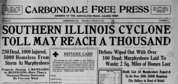
The Tri-State Tornado also made national and international news, as witnessed by these other newspaper front pages of March 19 and March 20.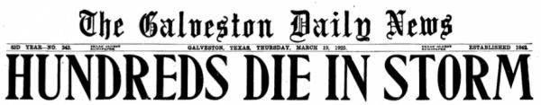


Much of the local economic downturn the Tri-State Tornado started, the Great Depression four-and-a-half years later finished. Most of the towns affected by the storm have significantly less population today than they did in 1925 and some of the smaller towns that were utterly destroyed have since been abandoned altogether.
The Tri-State Tornado set a number of records that are unlikely ever to be broken by any other tornado:
1. Most mysterious tornado in history
2. Longest lived tornado known worldwide
3. Longest uninterrupted track of any tornado known worldwide
4. Deadliest tornado in US history
5. Most tornado deaths in a single community
6. Most tornado deaths in a school
7. Earliest major tornado of any season on record
8. Affected the most states
9. Greatest forward speed for major tornado
10. Most missing victims, whose remains undoubtedly still lie in the deep woods into which they were flung
Today, well over 92 years later, surprisingly few people outside of the tri-state area that was directly affected by the storm have ever even heard of the 1925 Tri-State Tornado. It has largely disappeared into history, obscured by the passage of annual killer tornadoes and nearly a century of other severe weather events, which is why the nickname of this incredible one-of-a-kind tornado is now ‘The Forgotten Storm’.
Sources and Further Reading
Types of Thunderstorms
Severe Weather Glossary
U.S. Tornadoes
The Tri-State Tornado
The 1925 Tri-State Tornado Damage Path and Associated Storm System
March 18, 1925 — The Tri-State Tornado
Supercell Structure and Dynamics
Meteorological Analyses of the Tri-State Tornado Event of March 1925
Tri-State Tornado Pictures
Tri-State Tornado holds records 90 years later
Tornado Alley
Annual Disaster/Death Statistics for US Storms
1925 "Tri-State Tornado" Victims