The United States Redrawn with 50 Equal-Population States

By Minnesotastan in Politics on Jan 24, 2010 at 2:53 pm

This map is the creation of Neil Freeman, who noted that the current 50 states have populations ranging from a half million to 33 million.

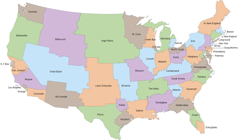
This Electoral Reform Map redivides the territory of the United States into 50 bodies of equal size – 281,421,906 divided by 50 is 5,616,997. This map shows one possible way to redraw the fifty states… The map was laid out with no political orientation or wealth. As a result, states may be favor one or the other parties.

In a U.S. Senate based on this map, each Senator would represent the same number of constituents.

Link, via James Fallows.


Email This Post
Tweet This Post 
Share This Post on Facebook

Tags: ,


Neat stuff from the NeatoShop:


  1. John Farrier
    Jan 24th, 2010 at 4:38 pm

    From the link:

    “However, it’s obvious that reforms are needed. the organization of the states should be altered.”

    Well, possibly. But a fundamental concept in the American republic is that the states are not administrative subdivisions of the whole, but by themselves, sovereign states. Hence the use of the term “state” rather than “province”. If the United States were (plural form of the verb) dissolved, the states would, legally speaking, continue to exist as governing entities.

    Sure, some electorates have disproportionate voting power in the Senate due to low populations, but that’s how the system was intentionally designed. Maybe it was a bad idea, but the map’s creator is wrong to suggest that the system has broken down. This is the system working as it was supposed to.

    It’s also worth noting that the mapmaker’s objective would require a constitutional amendment, as Article 4, Section 3 reads:

    “New states may be admitted by the Congress into this union; but no new states shall be formed or erected within the jurisdiction of any other state; nor any state be formed by the junction of two or more states, or parts of states, without the consent of the legislatures of the states concerned as well as of the Congress.”

    But it is an interesting looking map. Good find.

  2. mothr
    Jan 24th, 2010 at 4:41 pm

    While the map is neat, It’s worth noting that doing this would obviate the point of the senate. Congress exists to represent based by population. Senate exists explicitly because states have dispirate populations yet that doesn’t mean that the most populous states should have “more” say than the less populous. to quote wikipedia “This ensures equal representation of each state in the Senate”.

    If we were to redraw the states this way we would have no need for the senate at all.

  3. Squiggy
    Jan 24th, 2010 at 4:57 pm

    So he wants to redraw the borders every time the population changes to keep them equal? That’s silly.

    Imagine how much it would cost to relocate every seat of government and consolidate them, the historical impact, the vast empty states it would create (high plains for example), let alone the public outcry. It’s neat, but no thanks. What happens when the population changes, do it all again? lol

  4. su.wei
    Jan 24th, 2010 at 5:05 pm

    *sigh* they always leave out Alaska :/

  5. JohnR
    Jan 24th, 2010 at 5:15 pm

    Congressmen represent an equal number of people.
    Senators represent States. We should go back to the original system where Senators were appointed/elected by their State Legislature.

  6. Blahblah
    Jan 24th, 2010 at 6:43 pm

    Oregon really needs to split at the mountains. (East and West). The west sucks up all the state money and the East is very poor, and suffering. East could get proper Gov assistance, if it were its own state.

  7. trialex
    Jan 24th, 2010 at 6:52 pm

    This is how we already do it in Australia.

    The states are not divided this way, but the electoral boundaries are divided to approximately equal numbers. This means that each parliamentarian represents approximately the same number of people.

    The borders are “adjusted” every 25 or so years as the population grows/shifts.

  8. Jerse
    Jan 24th, 2010 at 8:03 pm

    What would the orange state by New York be called? It doesn’t have a name…

  9. Alician
    Jan 24th, 2010 at 8:13 pm

    “New states may be admitted by the Congress into this union; but no new states shall be formed or erected within the jurisdiction of any other state; nor any state be formed by the junction of two or more states, or parts of states, without the consent of the legislatures of the states concerned as well as of the Congress.”

    This is not relevant. Maine was once a part of Massachusetts and West Virginia was once part of Virginia.

  10. Alician
    Jan 24th, 2010 at 8:15 pm

    And BTW – West Virginia was made against Virginia’s will.

  11. justme
    Jan 24th, 2010 at 8:21 pm

    hey su.wei,
    I thought they did too (i’m an alaskan) but, if you read the notes under the map, hawaii and AK are grouped with other states. AK is grouped with “olympia”

  12. larryv
    Jan 24th, 2010 at 9:26 pm

    It’s good to see Missouri didn’t change much.

  13. chrisr
    Jan 24th, 2010 at 10:25 pm

    Big deal- That still leaves me living in KY.

  14. halieus
    Jan 24th, 2010 at 11:02 pm

    And all of Alaska and half of Canada would be Alaska. ;)

  15. Johnny Cat
    Jan 24th, 2010 at 11:48 pm

    I’m betting readers from around the world are looking at this and sighing a collective WGAF, but I like that the state called the Willamette, which was a race of natives that liked to give names to rivers that white men had trouble pronouncing. (Will AM it)

  16. GPSO 2010
    Jan 25th, 2010 at 9:20 am

    The population of the United States is 307 million plus, not 281 million.

    We grow by 1 person every 14 seconds for about 2.2 million increase every year.

  17. Vic
    Jan 25th, 2010 at 10:16 am

    This is poinless. It doesn’t give insight into anything really–nothing more than a population density map shows. It is at least a little comforting that the commentors understand the constitution and the whole purpose of the Senate and House of Representatives. Ever hear of the Great Compromise? Or did we stop teaching that in school because it isn’t PC or something?

  18. Walter Hawn
    Jan 25th, 2010 at 4:04 pm

    One commentator put the finger on the problem: the direct election of Senators.

    Senators were supposed to be the emissaries of State Governments, while Reps. were supposed to emanate from the people. This was thought to provide a useful tension. With direct election of senators, this tension is greatly diminished.

    H’ever, direct election was allowed, even demanded, because of some serious scandals, including the Teapot Dome thing, involving the purchase of seats from legislatures.

    Cunundrum.

  19. Ambling Poodle
    Jan 25th, 2010 at 9:17 pm

    from the link:
    “The electoral college is a time-honored system that, has only broken down three times in over 200 years.”
    –It has only broken down from the perspective of the losing party. Instead, just as John Ferrier says, it has worked exactly as designed.

    “States could be redistricted after each census – just like house seats are distributed now.”
    –The link posits this as an advantage! Imagine having your neighborhood change states multiple times, having to learn what new state laws apply to you. Imagine the burden to small business, changing employment laws and tax codes. And, over the long term, would we not have to do away with some state capitals (and capitols), and appoint new ones in areas of growing population?

    Interesting map of population density, but shoddy rationalization. Why keep the notion of states at all? Or the Senate?


Keep track of the comments with Comment RSS

Don't Miss: New Stuff | Bestsellers | The Cute Store
                   Funny T-Shirts

Need a gift? Get unforgettable gifts for:
Geeks | Pranksters | Kids | Hipsters | Shutterbugs

Lijit Search

Old school? Bookmark us! RSS Feed Twitter Facebook Page