The Earth's Delicious Core

Posted by Jill Harness in Arts & Crafts on June 16, 2009 at 8:38 pm


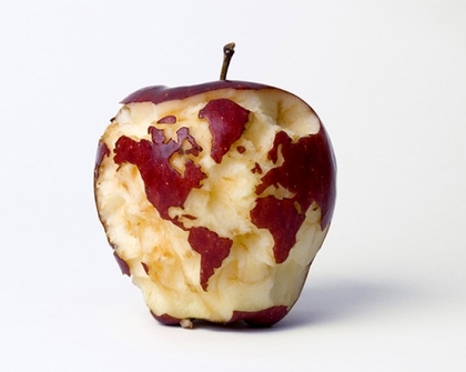
This apple is in the portfolio of artist Kevin Van Aelst, along with quite a few other neat visual works. The only problem I have is that he forgot Madagascar.

Link


Previous post
this post? Please Email this               
Next post

Tags: , ,


FUN PRODUCTS FROM THE NEATORAMA SHOP:


COMMENT

19 comments to "The Earth's Delicious Core"

  1. John Cleave
    June 16th, 2009 at 9:35 pm

    Madagascar just looked so yummy!

  2. mackenzie
    June 16th, 2009 at 9:53 pm

    The beef i have with this is that greenland is not that size and this map type is only appropriate for flat surfaces. with an apple being somewhat round, there is no exuce to not make it more accurate when it comes to landmass size.

  3. DebG
    June 16th, 2009 at 10:20 pm

    Madagascar must have gotten caught in his teeth.

  4. Dan0
    June 16th, 2009 at 10:38 pm

    I agree with Mackenzie. He should have used a globe instead of a map to make this, because this projection makes the poles appear much larger than they should be. Greenland and Northern Canada are much too big.

    Hooray undergraduate geography degree

  5. Dan0
    June 16th, 2009 at 10:39 pm

    still pretty darn neat though.

  6. laly
    June 17th, 2009 at 12:17 am

    An apple a day keeps the geograph away!

    As a Canadian, I'm quite satisfied with the size of Canada. But, Greeland is indeed too BIG!

  7. FrankP
    June 17th, 2009 at 12:34 am

    Denmark has sunk beneath the waves..

  8. Fulgore
    June 17th, 2009 at 1:13 am

    He also forgot Baja California Norte y Sur. For those who are wondering, it is a big Mexican Penninsula, south of San Diego.

  9. Eibmoz
    June 17th, 2009 at 1:13 am

    Crispy,tasty, Madagascar....

  10. nate
    June 17th, 2009 at 1:33 am

    lawl you spelled his name wrong

  11. Alex
    June 17th, 2009 at 1:37 am

    FTFY, Jill.

  12. Suzie | Roof Repairs
    June 17th, 2009 at 5:13 am

    I think that we can forgive him for leaving out one place it looks amazing

  13. D Bozko
    June 17th, 2009 at 6:46 am

    The United States, Canada, Mexico and Central America looks like a chicken...of sorts. Oh and Florida is kinda puny too. "A" for effort, C- for execution.

  14. C
    June 17th, 2009 at 8:41 am

    Amazing! but no Bahamas...

  15. MadMolecule
    June 17th, 2009 at 9:50 am

    Wonder how he did that without the apple turning brown?

  16. Tiago Landi
    June 17th, 2009 at 11:52 am

    Where are the Falkland Islands!?!? LOL!
    And HTF is Greenland bigger than South America??! I'd guess South America is like, 10x bigger than Greenland.
    Anyway, I'd like to give a bite!

  17. cavalaxis
    June 17th, 2009 at 1:26 pm

    It's an apple, folks. If you've ever tried to carve something in that medium with any kind of accuracy, you'd be a little more forgiving.

    This is not a chart intended to be used for navigation. It's art.

    ~noms~

  18. matt
    June 17th, 2009 at 5:22 pm

    forget madagascar, where is New Zealand? there is a weird looking blob where it should be... how insulting.

  19. Maeveone
    June 20th, 2009 at 2:35 am

    Typical he did the side without Australia on it...


PLEASE LEAVE A COMMENT

Neatorama Comment Policy
You don't have to register or login to comment, but it's easier if you do so. Comments aren't censored, but those that are abusive or off-topic may be edited or deleted.


Stay updated on the comments with Comment RSS